National Land Cover, Change and Degradation Status in Iraq (2000–2020)
1. Land cover in 2000
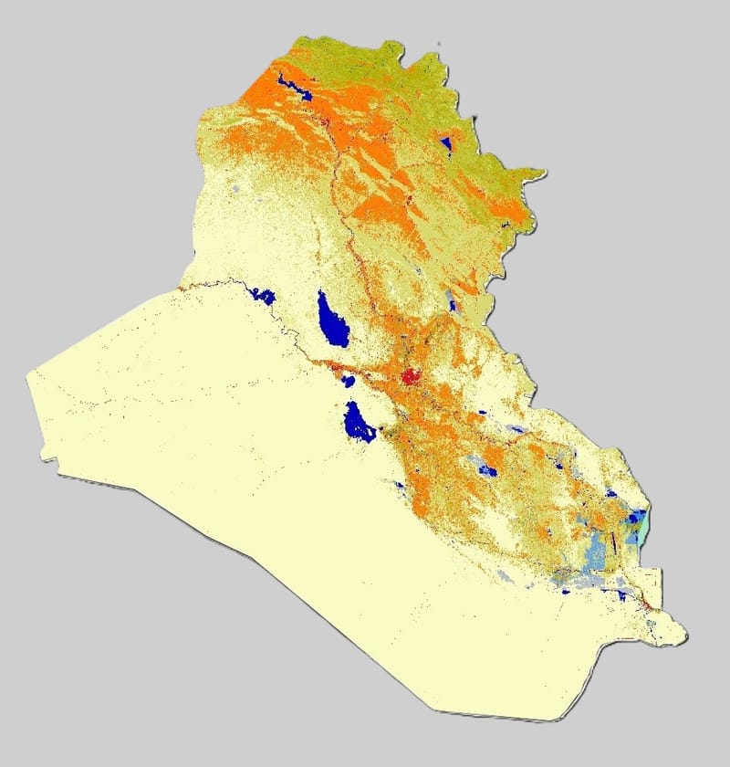
The 2000 land-cover map (Figure 1) and composition chart (Figure 2, Table 1) show that Iraq at the turn of the century was dominated by arid and semi-arid ecosystems:
- Desert covered 264,456 km² (60.7% of the national territory), occupying most of western and southern Iraq.
- Grasslands (low, medium and high density) together occupied 108,021 km² (24.8%), forming a broad belt across the north and along the Tigris–Euphrates corridor where rainfall and soil conditions allow sparse to moderate vegetation.
- Low-density grassland alone accounted for 73,644 km² (16.9%).
- Natural woody vegetation(shrubland and forest) was very limited:
- Shrubland: 119 km² (0.03%)
- Forest: 148 km² (0.03%), mainly confined to small patches in the mountainous northeast.
- Wetlands (all types combined) – including marshes with sparse or grassy vegetation, shrub wetlands and forested wetlands – covered ≈6,862 km² (1.6%). These were concentrated in:
- the Mesopotamian marshes in the south,
- riparian corridors along the Tigris and Euphrates,
- and scattered depressions and seasonal wetlands in central and northern Iraq.
- Open water (rivers, lakes, reservoirs) accounted for 6,004 km² (1.4%).
- Cropland occupied 46,723 km² (10.7%), reflecting the long-established agricultural systems:
- irrigated agriculture along the Tigris–Euphrates and its canals,
- rainfed agriculture in the northern governorates.
- Built-up areas (urban and peri-urban land) covered 3,682 km² (0.84%), concentrated around major cities such as Baghdad, Mosul, Basrah and Erbil.
Overall, the 2000 baseline depicts a landscape where natural and semi-natural land covers (desert, grasslands, wetlands and sparse woody vegetation) dominate, with agricultural and urban land still occupying a relatively modest share of the national area.
(Full resolution: 1_LC composition map 2000.JPG)
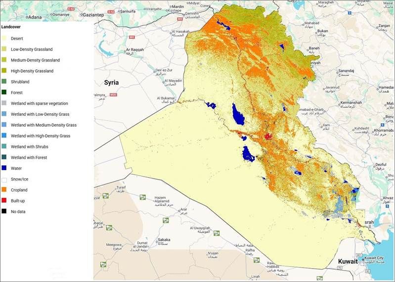
Figure 1. National land cover of Iraq in 2000.
Land-cover map derived from the GLCLU v2 dataset for the year 2000, showing the spatial distribution of desert, grasslands, wetlands, cropland, built-up areas and other classes across Iraq.
(Full resolution: 2_LC chart 2000.png)
Figure 2. Land-cover composition of Iraq in 2000.
Bar chart summarizing the area (km²) of each land-cover class in 2000, based on GLCLU v2 at 90-m resolution.
Table 1. Land-cover statistics for Iraq in 2000.
Area (km²) and percentage of national territory for each land-cover class in 2000 (GLCLU v2, 90-m resolution).
Label | Area (km²) |
Desert | 264,456.33 |
Low-Density Grassland | 73,643.95 |
Medium-Density Grassland | 23,622.94 |
High-Density Grassland | 10,754.35 |
Shrubland | 119.299 |
Forest | 147.667 |
Wetland with sparse vegetation | 3,098.06 |
Wetland with Low-Density Grass | 2,728.17 |
Wetland with Medium-Density Grass | 618.861 |
Wetland with High-Density Grass | 394.781 |
Wetland with Shrubs | 6.68 |
Wetland with Forest | 14.988 |
Water | 6,004.40 |
Snow/Ice | 0 |
Cropland | 46,722.96 |
Built-up | 3,681.62 |
No data | 0 |
(Download: 3_LC stats 2000.csv)
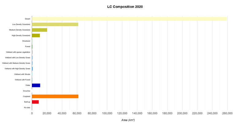
2. Land cover in 2020
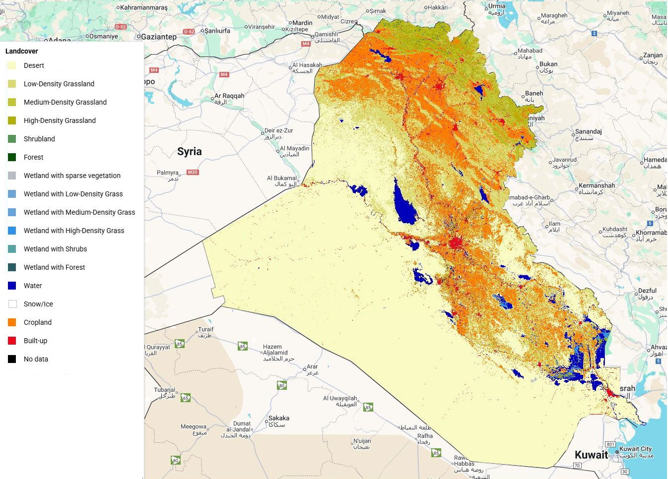
By 2020, the national land-cover composition had changed in ways that reflect two decades of demographic growth, agricultural expansion, hydrological change and ecosystem disturbance (Figure 3, Figure 4, Table 2):
- Desert remained the dominant class with 258,889 km² (59.4%). The overall extent is similar to 2000, but there are localised expansions and contractions along the agricultural and rangeland frontiers.
- Grasslands decreased to 92,286 km² (21.2%):
- Low-density grassland declined from 16.9% to 14.1% of the national area (loss of 12,129 km²).
- Medium-density grassland decreased by 3,436 km², while high-density grassland remained almost stable (slight decline of 170 km²).
These changes point to pressure on rangelands, both through conversion and changes in vegetation density.
- Woody vegetationshows a mixed signal:
- Shrubland slightly decreased to 100 km².
- Forest increased to 247 km². Although still a very small fraction of the country (~0.06%), this indicates some localised forest recovery or improved detection in mountainous and riparian zones.
- Wetlandsexperienced a pronounced contraction:
- Total wetland area (all wetland subclasses) fell from ≈6,862 km² to ≈2,810 km², a net loss of 4,052 km² (≈59% of the 2000 wetland extent).
- The most significant declines occurred in “wetland with sparse vegetation” and “wetland with low-density grass”, which together lost more than 4,300 km².
- Water bodies expanded substantially to 10,987 km² (2.5%). This reflects:
- the partial restoration of the southern marshes after 2003,
- expansion or filling of reservoirs and irrigation lakes,
- and interannual hydrological variability captured in the 2020 epoch.
- Cropland increased markedly to 61,617 km² (14.1%), an addition of 14,894 km² (+32%) compared with 2000.
- Built-up land more than doubled, from 3,682 km² (0.84%) to 9,080 km² (2.1%), an increase of 5,398 km² (+147%), reflecting rapid urbanization and peri-urban expansion around major cities and along transport corridors.
Taken together, the 2020 snapshot shows a more intensively used landscape, with larger cropland and urban footprints, reduced natural grasslands and wetlands, and somewhat greater open water extent.

(Full resolution: 4_LC composition map 2020.JPG)
Figure 3. National land cover of Iraq in 2020.
Land-cover map for 2020 from GLCLU v2, illustrating changes in the extent of cropland, built-up areas, wetlands and other classes compared with 2000.
(Full resolution: 5_LC chart 2020.png)
Figure 4. Land-cover composition of Iraq in 2020.
Bar chart showing the area (km²) of each land-cover class in 2020, derived from GLCLU v2 at 90-m resolution.
Table 2. Land-cover statistics for Iraq in 2020.
Area (km²) and percentage of national territory for each land-cover class in 2020 (GLCLU v2).
Label | Area (km²) |
Desert | 258,888.99 |
Low-Density Grassland | 61,514.82 |
Medium-Density Grassland | 20,186.89 |
High-Density Grassland | 10,584.16 |
Shrubland | 100.328 |
Forest | 246.713 |
Wetland with sparse vegetation | 900.553 |
Wetland with Low-Density Grass | 564.375 |
Wetland with Medium-Density Grass | 531.326 |
Wetland with High-Density Grass | 791.352 |
Wetland with Shrubs | 3.787 |
Wetland with Forest | 18.252 |
Water | 10,986.54 |
Snow/Ice | 0 |
Cropland | 61,617.17 |
Built-up | 9,079.79 |
No data | 0 |
(Download: 6_LC stats 2020.csv)
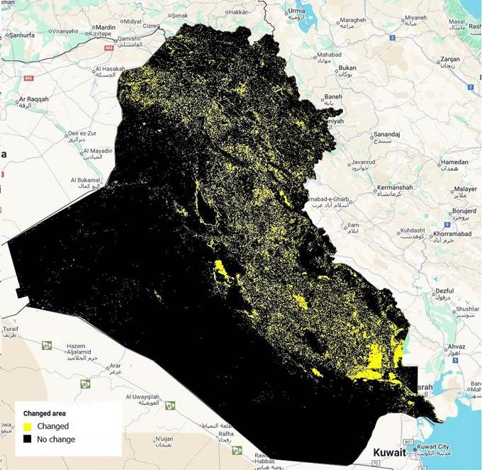
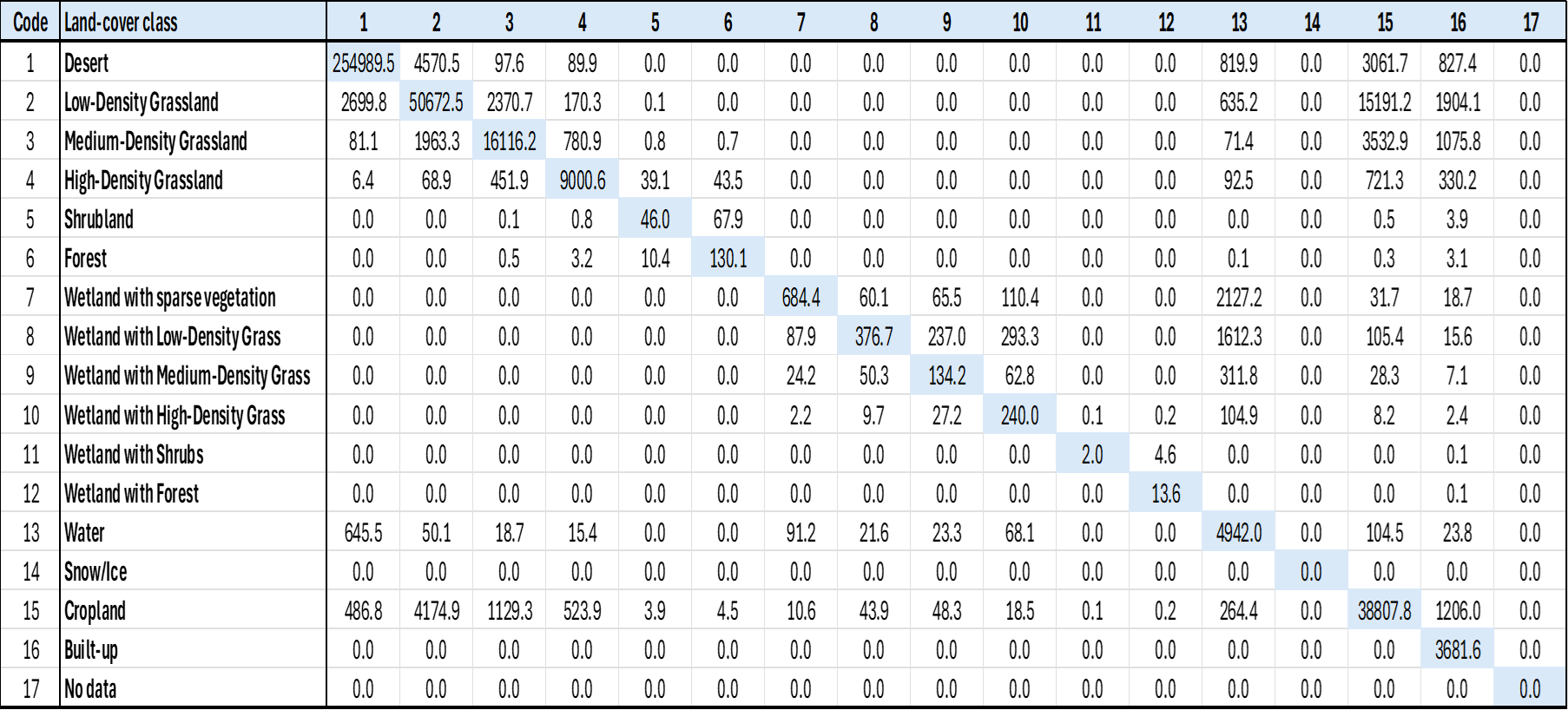
3. Land cover changes between 2000 and 2020
3.1 Overall magnitude of change
The land-cover change map and change matrix (Figure 5 and Table 3) reveal that:
- The total area that changed land-cover class between 2000 and 2020 is ≈56,178 km², equivalent to 12.9% of the national territory.
- Conversely, about 87% of Iraq remained in the same land-cover class over the 20-year period.
Change is highly concentrated along the:
- Tigris–Euphrates river system and associated irrigation schemes;
- northern rainfed agricultural belt;
- southern marshes and coastal plain;
- and around major cities and infrastructure corridors.
Large parts of the western and south-western desert remained stable.
3.2 Dominant transitions
Analysis of the transition matrix highlights several key processes:
- Cropland expansionfrom natural or semi-natural covers is the single largest transition type:
- 19,562 km² changed into cropland, representing about 35% of all changed area.
- Major sources include grasslands, wetlands and desert fringes, especially along the river corridors and in the northern plains.
- Urbanization (conversion to built-up land) accounts for 5,355 km² (9.5% of changed area), capturing the growth of cities and towns.
- Wetland loss (conversion of wetlands to non-wetland terrestrial classes, including cropland and bare land) totals 4,203 km² (7.5% of changed area).
- Desertification processes—where vegetated land converted to desert—amount to 3,912 km² (7.0% of changed area). These changes occur mainly along the desert–rangeland and desert–cropland transition zones.
- Vegetation density loss in non-desert areas contributes 2,692 km² (4.8% of changed area), indicating degradation within grasslands and other vegetated classes without a full class conversion.
On the positive side, several transitions reflect ecological improvement:
- Desert greening (desert becoming vegetated) covers 7,838 km² (14.0% of changed area).
- Ecological restoration (cropland or degraded land reverting to natural vegetation) accounts for 5,835 km² (10.4% of changed area).
- Vegetation density gain adds 4,157 km² (7.4% of changed area).
- Water gain (permanent or seasonal water appearing where it was absent) occurs over 1,881 km², while wetland gain accounts for 324 km².
These patterns indicate that, alongside clear degradation processes, there are also significant areas of recovery, particularly in relation to marsh rehabilitation and vegetation re-establishment in some regions.
(Full resolution: 5_LC chart 2020.png)
Figure 5. Land-cover change in Iraq between 2000 and 2020.
Binary change/no-change map highlighting all pixels that changed land-cover class over the period 2000–2020. x
Table 3. Land-cover transition matrix for Iraq, 2000–2020 (17 × 17 classes).
Matrix of land-cover transitions from 2000 (rows) to 2020 (columns), including stable areas on the diagonal; values are in km².
(Download: 8_Change Matrix.csv)
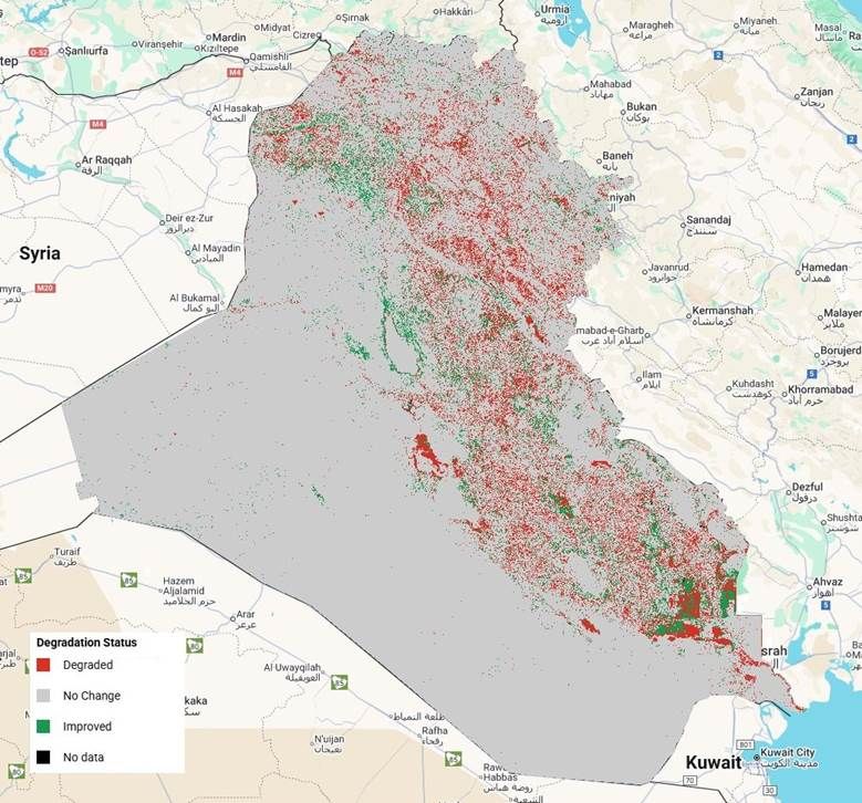
4. Land degradation status based on land cover change
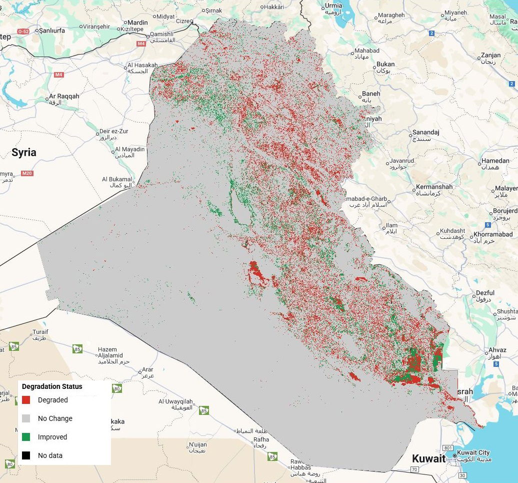
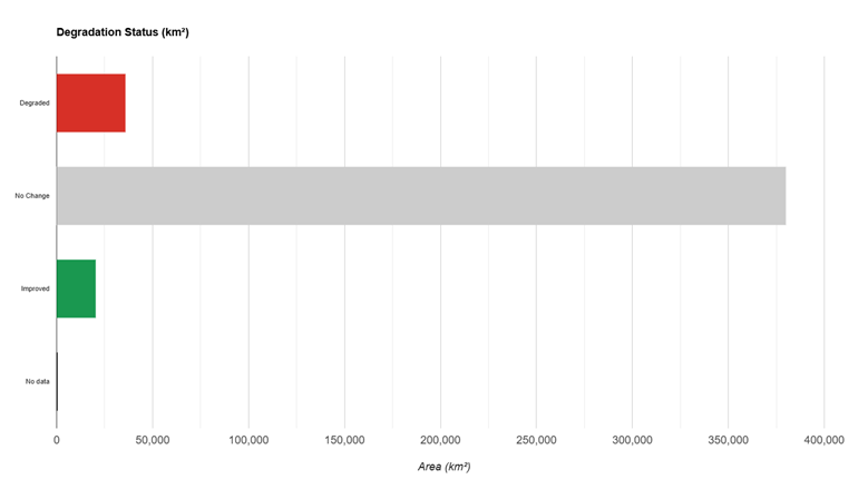
Using the UNCCD SDG 15.3.1 land-degradation framework, land-cover transitions were grouped into three main status classes: Degraded, Improved and No Change (Figure 6, Figure 7, Table 4).
4.1 National proportions
- Degraded land: 35,734 km², equivalent to 8.2% of Iraq’s land area.
- Improved land: 20,186 km² (4.6%).
- No change: 379,834 km² (87.1%).
- No data: 261 km² (0.06%).
Thus, around 12.8% of Iraq experienced significant land-cover change, of which about two-thirds is classified as degradation and one-third as improvement.
4.2 Spatial patterns of degradation and improvement
- Degraded areas(shown in red on the degradation-status map) are concentrated:
- in the central and southern agricultural belt, where cropland expansion, salinisation and vegetation decline are prevalent;
- along the edges of the southern marshes, where wetland loss and conversion to cropland or bare land occurred;
- in northern rainfed zones, where cropland expansion and vegetation density loss affect rangelands;
- and around urban centres, where urbanisation replaces agricultural and natural land.
- Improved areas(in green) cluster mainly:
- in parts of the Mesopotamian marshes and adjacent floodplains, where re-flooding and restoration increased water and wetland cover;
- in sections of the northern and central plains, where vegetation greening or restoration (possibly linked to improved management or favourable climatic periods) is detected;
- and in some reservoirs and lakes, where water extent increased.
The large expanse of “No change” (grey) covers most of the western desert, plateau areas and stable agricultural or natural systems.
(Full Resolution: 9_Degradation Status map.JPG)
Figure 6. Land-degradation status based on land-cover change (2000–2020).
Map classifying each pixel as degraded, improved, no change or no data according to the UNCCD SDG 15.3.1 land-degradation framework.
(Full Resolution: 10_Degradation Status chart.png)
Figure 7. Area of degraded, improved and stable land in Iraq (2000–2020).
Bar chart showing the total area (km²) mapped as degraded, improved or with no change in land-degradation status.
Table 4. Land-degradation status statistics for Iraq (2000–2020).
Area (km²) and percentage of national territory classified as degraded, improved, no change or no data according to the UNCCD SDG 15.3.1 methodology.
Label | Area (km²) |
Degraded | 35,734.3 |
No Change | 379,833.6 |
Improved | 20,186.2 |
No data | 260.9 |
(Download: 11_Degradation Status stats.csv)
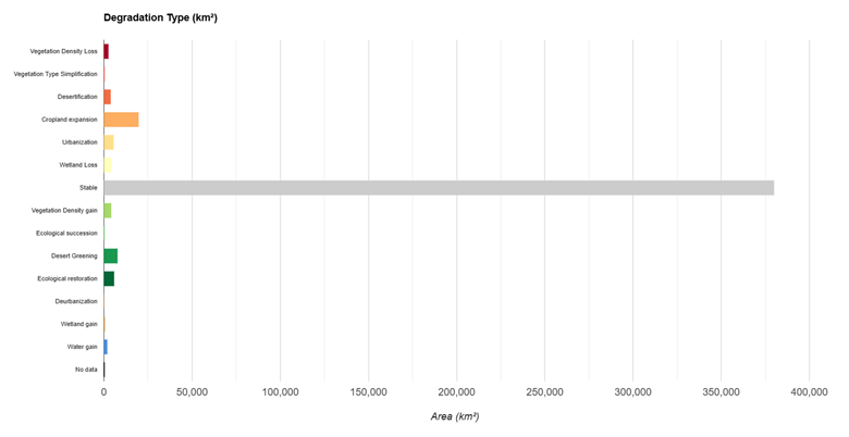
5. Degradation and improvement types
The degradation-type map and chart (Figure 8, Figure 9, Table 5) disaggregate the degraded and improved areas into specific process categories, following the UNCCD typology.
5.1 Degradation processes
The main degradation processes and their contributions are:
- Cropland expansion – 19,562 km²
- 54.7% of all degraded area and 4.5% of the national territory.
- Represents conversion of natural grasslands, wetlands and other vegetated land into cropland.
- Spatially concentrated in:
- the Tigris–Euphrates corridor,
- the northern rainfed belt,
- and areas around the southern marsh fringe.
- While cropland expansion can support food security, it is classified as land degradation in this framework because it generally reduces ecosystem integrity and biodiversity compared with natural vegetation.
- Urbanisation – 5,355 km²
- 15.0% of degraded area.
- Reflects the spread of built-up land into former cropland and natural areas around major cities and along highways.
- Associated with irreversible soil sealing and loss of productive land.
- Wetland loss – 4,203 km²
- 11.8% of degraded area.
- Indicates conversion of wetland classes to cropland, bare or non-wetland vegetation.
- Particularly relevant in the southern marshes and some inland depressions, with implications for biodiversity, fisheries and local climate regulation.
- Desertification – 3,912 km²
- 11.0% of degraded area.
- Occurs where grasslands or other vegetated covers transitioned to desert.
- Concentrated along desert margins and degraded rangelands, reflecting processes such as overgrazing, soil erosion and prolonged drought.
- Vegetation density loss – 2,692 km²
- 7.5% of degraded area.
- Captures areas where vegetation cover became sparser without a full class change, particularly in rangelands and agricultural mosaics.
- Vegetation type simplification – 11 km²
- A very minor component at national scale, indicating limited cases where more complex vegetation transitioned to simpler formations.
5.2 Improvement processes
Improvement types mirror processes where land condition has improved relative to the 2000 baseline:
- Desert greening – 7,838 km²
- 38.8% of all improved area.
- Represents transitions from desert to vegetated classes (grassland or shrub/forest).
- Indicates expansion of vegetation into formerly bare areas, which may reflect favourable climatic periods, irrigation schemes, shelterbelts or other land-management interventions.
- Ecological restoration – 5,835 km²
- 28.9% of improved area.
- Involves transitions from cropland or degraded land back to natural vegetation.
- Suggests that in some locations, cropland abandonment, afforestation, or rangeland rehabilitation have allowed natural ecosystems to recover.
- Vegetation density gain – 4,157 km²
- 20.6% of improved area.
- Denotes increases in vegetation cover within existing vegetated classes, often in rangelands or mixed systems.
- Water gain – 1,881 km²
- 9.3% of improved area.
- Includes the re-expansion of water surfaces in marshes and reservoirs, contributing positively to ecological condition in the UNCCD framework.
- Wetland gain – 324 km²
- 1.6% of improved area.
- Captures conversion of non-wetland land to wetland classes, notably as part of marsh restoration efforts.
- Ecological succession – 151 km²
- A smaller component, where simpler vegetation types evolved into more complex or woody formations, signalling natural recovery.
- De-urbanisation – 0 km²
- Not detected at this scale; once land became built-up, it generally remained so over the 20-year period.
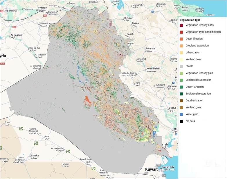
(Full Resolution: 12_Degradation Type map.JPG)
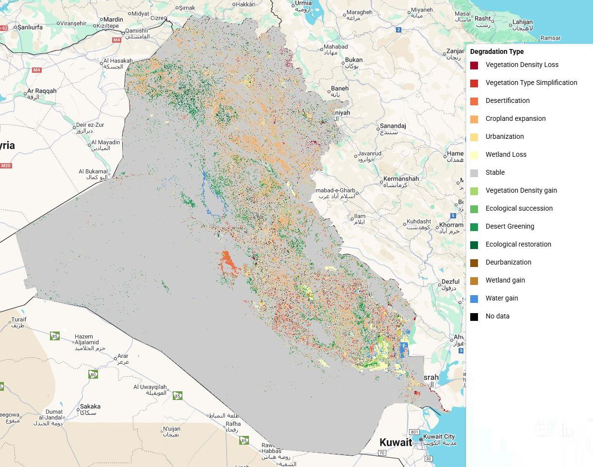
Figure 8. Land-degradation and improvement types in Iraq (2000–2020).
Map of the dominant degradation and improvement processes (e.g. cropland expansion, urbanization, wetland loss, desert greening, ecological restoration) derived from land-cover transitions.
(Full Resolution: 13_Degradation Type chart.png)
Figure 9. Area of each land-degradation and improvement type (2000–2020).
Bar chart summarizing the area (km²) affected by each degradation/improvement type across Iraq.
Table 5. Land-degradation and improvement types in Iraq (2000–2020).
Area (km²) and percentage of national territory affected by each degradation/improvement type (vegetation density loss/gain, cropland expansion, urbanization, wetland loss/gain, desertification, desert greening, ecological restoration, etc.).
Label | Area (km²) |
Vegetation Density Loss | 2,692.04 |
Vegetation Type Simplification | 10.547 |
Desertification | 3,911.66 |
Cropland expansion | 19,562.31 |
Urbanization | 5,354.53 |
Wetland Loss | 4,203.23 |
Stable | 379,833.57 |
Vegetation Density gain | 4,157.44 |
Ecological succession | 150.666 |
Desert Greening | 7,838.30 |
Ecological restoration | 5,834.90 |
Deurbanization | 0 |
Wetland gain | 323.794 |
Water gain | 1,881.15 |
No data | 260.935 |
(Download: 14_Degradation Type stats.csv)
6. Key conclusions and implications
- Dominance of arid landscapes with significant human expansion
Iraq remains predominantly desert and semi-arid rangeland, but cropland and urban areas expanded by more than 20,000 km² between 2000 and 2020. This intensifies pressure on water resources, soils and biodiversity, especially in the Tigris–Euphrates system and northern plains. - Substantial loss of wetlands despite partial marsh restoration
Although open water increased—partly due to marsh reflooding and reservoir dynamics—total wetland area fell by about 4,000 km² (≈59%), underlining the vulnerability of marshes and seasonal wetlands to drainage, conversion and hydrological change. - Land degradation is widespread but not uniform
Around 8.2% of Iraq’s land area is classified as degradedbased on land-cover change. Degradation is concentrated in:- agricultural frontiers,
- marsh and wetland margins,
- and around expanding cities.
Cropland expansion and urbanisation together represent nearly 70% of all degraded area.
- Important pockets of improvement and restoration
At the same time, 4.6% of the national territory shows improvement, driven by desert greening, ecological restoration and vegetation densification. These processes demonstrate the potential for positive change when hydrological conditions and land-management practices are favourable. - Stable core areas, dynamic hotspots
The majority (≈87%) of Iraq did not experience a change in land-cover class over 20 years, but the remaining 13% is highly dynamic and environmentally critical. These hotspots warrant targeted monitoring and management. - Policy relevance
- The dominance of cropland expansion as a degradation process highlights the need for sustainable agricultural intensification, salinity management and protection of remaining natural rangelands and wetlands.
- The identified improvement zones, especially in the southern marshes and some northern landscapes, can serve as success stories and learning sites for restoration initiatives.
- Integrating these land-cover and degradation layers into national planning, water-management strategies and climate-change adaptation plans will support Iraq’s efforts to achieve SDG 15.3 (land degradation neutrality).